Search filter
Clear filters
-
- GFZ
- Department 1 Geodesy
- Section 1.1 Space Geodetic Techniques
- Section 1.2 Global Geomonitoring and Gravity Field
- Section 1.3 Earth System Modelling
- Section 1.4 Remote Sensing and Geoinformatics
- Section 1.5 Space Physics and Space Weather
- Department 2 Geophysics
- Section 2.2 Geophysical Imaging
- Section 2.3 Geomagnetism
- Section 2.4 Seismology
- Section 2.6 Seismic Hazard and Risk Dynamics
- Department 4 Geosystems
- Section 4.2 Geomechanics and Scientific Drilling
- Section 4.3 Geoenergy
- Department 5 Geoinformation
- Section 5.1 Data and Information Management
- Section 5.2 eScience Centre
-
- Archaeomagnetism
- Controlled Source Seismology
- Data Management/Data Services
- Electromagnetics
- Geodesy and Gravity
- Geoenergy
- Geology
- Geomagnetism
- Geomagnetism and Paleomagnetism
- Geophysics
- Geosciences
- Geothermal Energy
- Global Change
- GNSS
- Gravimetry
- Hydrology
- Informatics
- Life Sciences
- Magnetotellurics
- Natural Hazards
- Palaeomagnetism
- Physical Properties of Rocks
- Remote Sensing
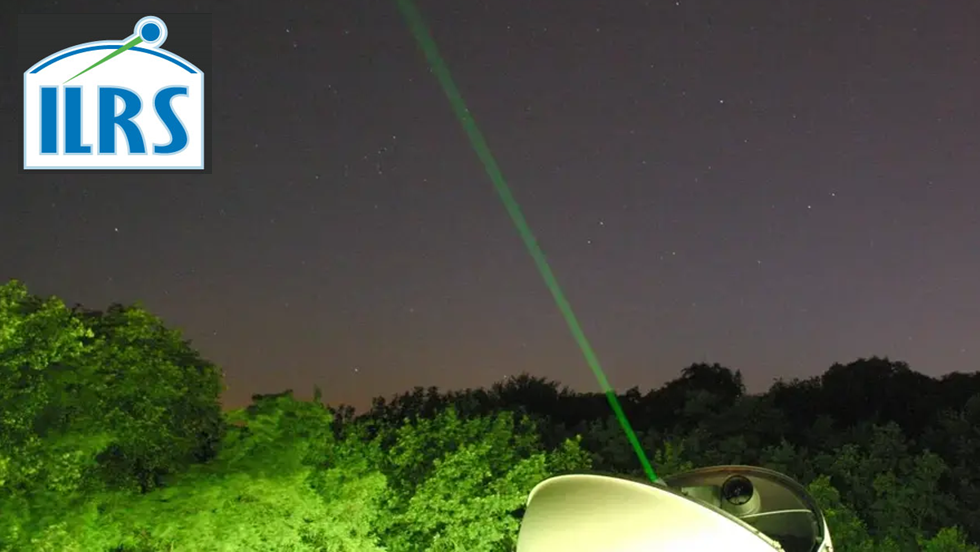
- Satellite Laser Ranging
- Seismic Hazard
- Seismology
- Space Geodesy
- Space Weather
- Tectonophysics
-
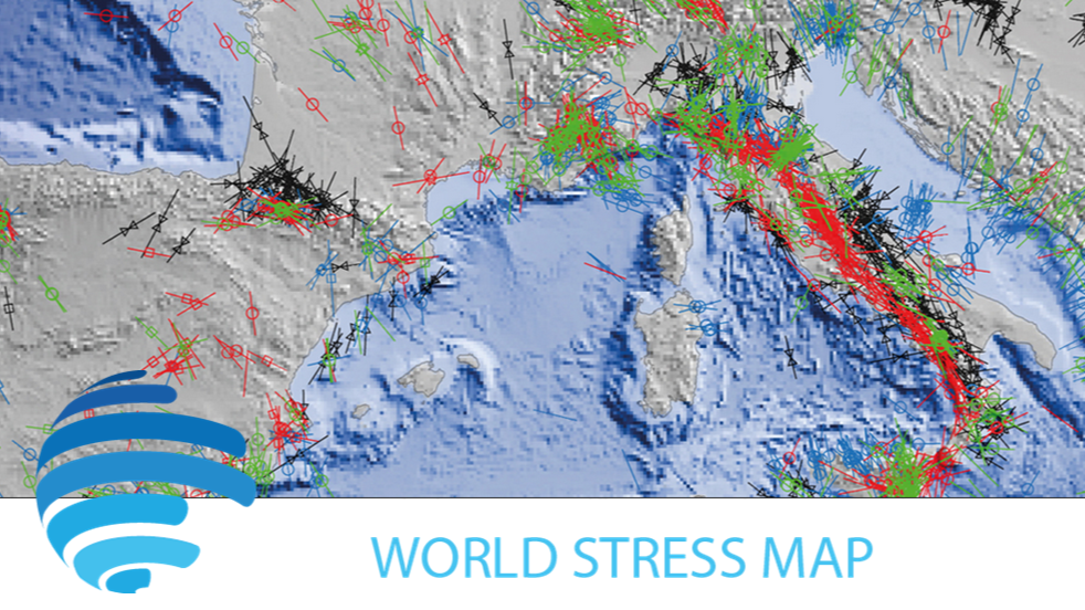
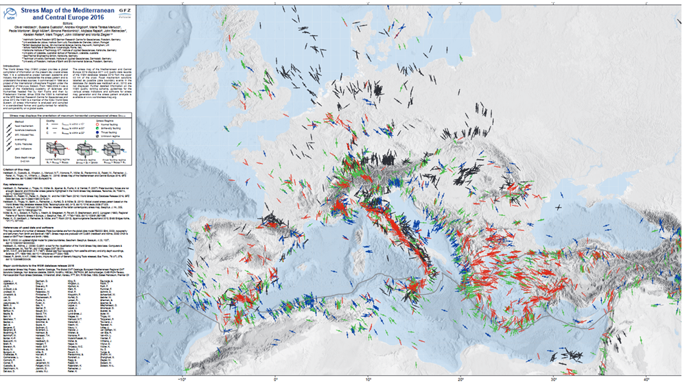
- Contemporary Crustal Stress
- Controlled Source Seismological Data
- Earth Magnetic Field Data
- Earth Orientation Parameters
- Final Products
- Geomagnetic Field Models
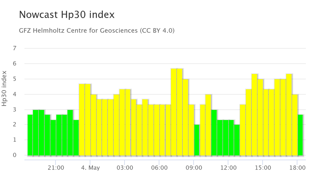
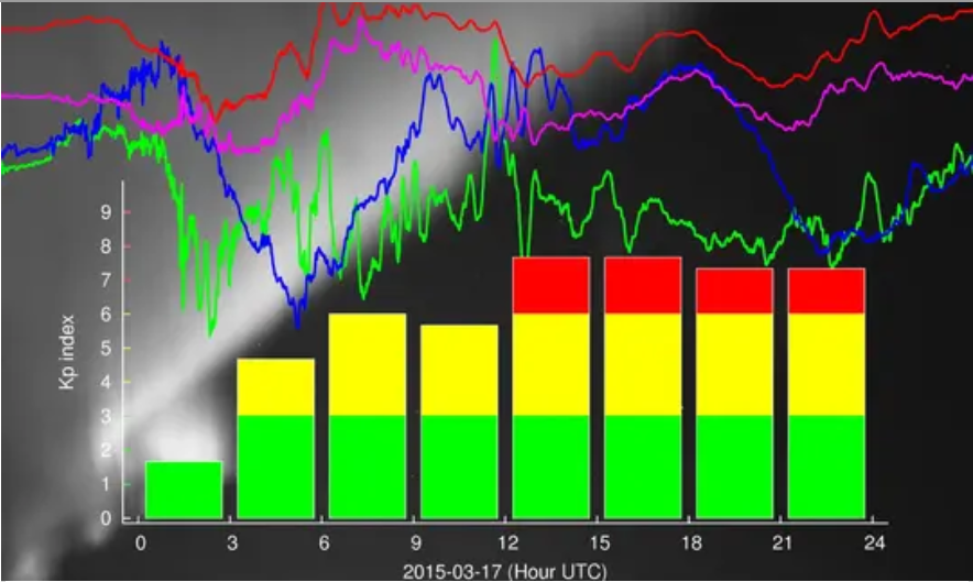
- Geomagnetic index
- GIS
- Global Gravitational Models
- GNSS Data
- GNSS Station and Satellite Metadata
- Heat Flow Data
- Historical Earthquakes
- Magnetic Data
- Magnetotelluric Data
- Observation Data and Derived Products for the Global Navigation Satellite Systems (GNSS)
- Passive Seismological Data
- Polar Motion
- Precession/Nutation
- Precise Station Coordinates
- Processed GPS Products
- Rapid Products
- Raw Gravity and Local Pressure Records and Products
- Satellite Clock Corrections
- Satellite Orbits
- Seismic Events
- Temporal Models
- Topography Related Models
- Ultra-rapid Products
- Universal Time
Data Services

Declination Calculator for the International Geomagnetic Reference Field IGRF
The declination calculator provides declination values for any location on Earth and any time between 1900 and 2025. The calculation is based on the International Geomagentic Reference Field (IGRF) which describes the geomagnetic core field. The cal…

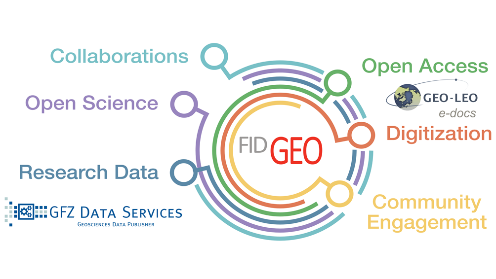
FID GEO - Specialised Information Service Geosciences
The Specialised Information Service for Geosciences (FID GEO - Fachinformationsdienst Geowissenschaften) is an information service of the GFZ Helmholtz Centre for Geosciences in Potsdam (GFZ) and the Goettingen State and University Library. Funded b…
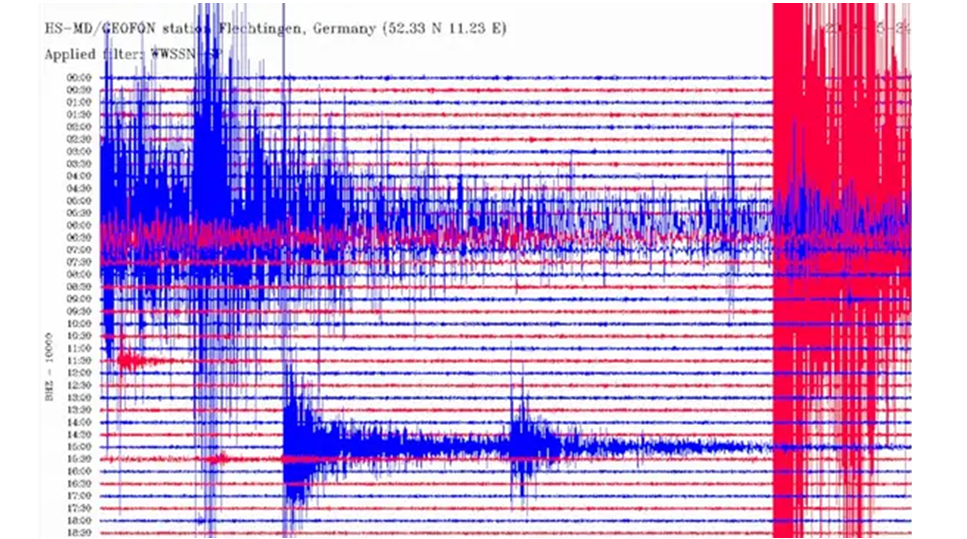
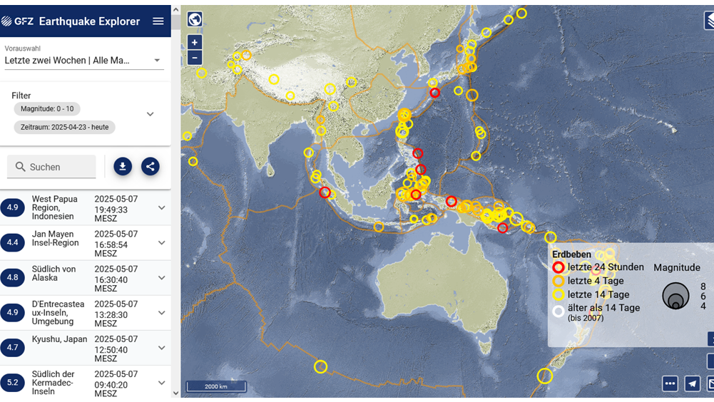

GEOFON Eqinfo - GEOFON Global Earthquake Monitoring System
All real time data streams from GEOFON stations as well as around 900 additional real-time stations from international partners are used to determine rapid automatic location estimates for all globally recorded earthquakes and most regional ones. Th…
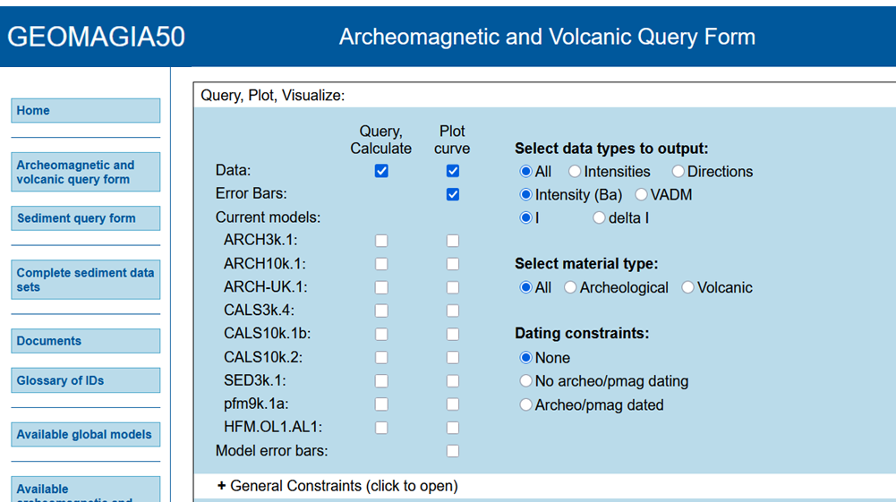
GEOMAGIA50 – Paleomagnetic and Chronological Data for the Past 50 Ka
The GEOMAGIA50 database is an international collaboration to provide easy access to published archeomagnetic/volcanic and sediment paleomagnetic and chronological data for the past 50,000 years. GEOMAGIA50 has been funded by the US National Science …

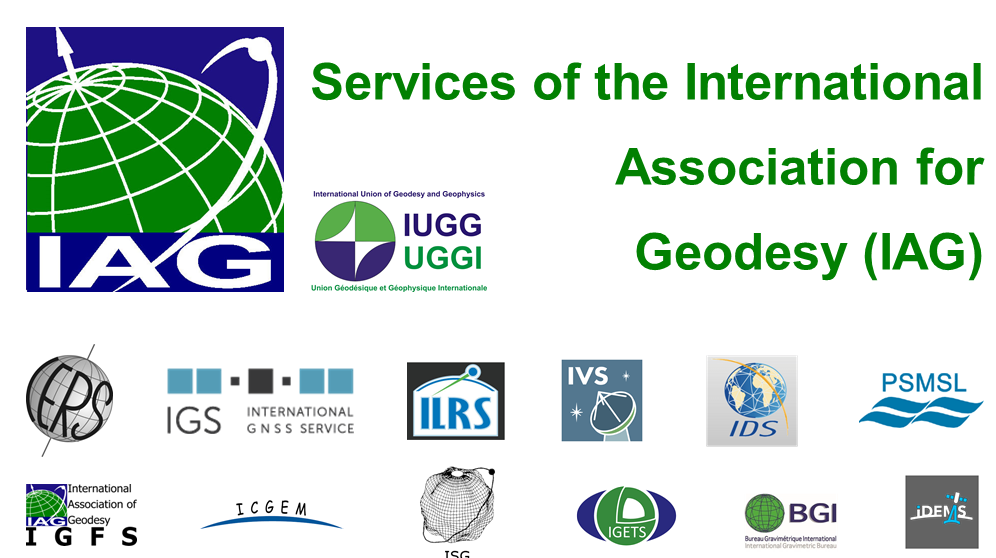
IAG Services - Services of the International Association of Geodesy (IAG Services)
The International Association of Geodesy (IAG) is the scientific organization in the field of geodesy. It promotes scientific cooperation and research in geodesy on a global scale and contributes to it through its various research bodies. It is a me…

ICDP International Continental Scientific Drilling Programme
The International Continental Scientific Drilling Program (ICDP) is a multinational program to further and fund geosciences in the field of Continental Scientific Drilling. Scientific drilling is a critical tool in understanding of Earth processes a…

ICGEM - International Centre for Global Earth Models
The determination of Earth’s global gravity field is one of the main tasks of geodesy: it serves as a reference for geodesy itself and provides essential information about the Earth, its interior and its fluid envelope for all geosciences. Thus, it …

IERS - International Earth Rotation and Reference Systems Service
The International Earth Rotation and Reference Systems Service (IERS) was established in 1987 by the International Astronomical Union and the International Union of Geodesy and Geophysics. The primary objectives of the IERS are to serve the astronom…
IGETS Database - Database of the International Geodynamics and Earth Tide Service
The International Geodynamics and Earth Tide Service (IGETS) is one of five services coordinated by the International Gravity Field Service (IFGS) of the International Association of Geodesy (IAG). The main objective of IGETS is to monitor temporal …

IVS - International VLBI Service for Geodesy and Astronomy
Very Long Baseline Interferometry (VLBI) is a highly accurate technique, used since the 1970s in geodesy that has delivered groundbreaking scientific discoveries. This technique allows scientists to measure global distances with millimeter accuracy;…
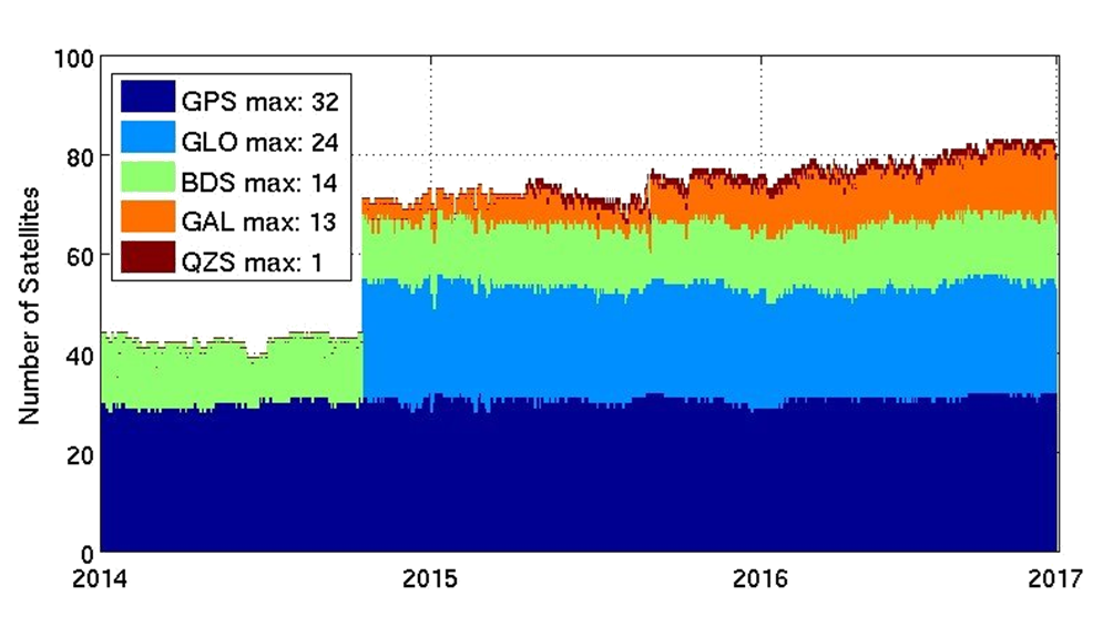
MGEX - Analysis Center of the Multi-GNSS Experiment
The Multi GNSS Experiment (MGEX) was initiated by the IGS in 2012. In MGEX all available signals of the new GNSS satellites are analysed. Currently, seven IGS analysis centers generate consistent and precise orbits and clock corrections of the new s…
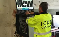
OSG ICDP | Operational Support Group of the International Continental Scientific Drilling Program
The Operational Support Group of the International Continental Scientific Drilling Program, ICDP, situated at GFZ, provides downhole logging services and access to utilize the ICDP instrument pool for PIs of successful ICDP proposals. ICDP is a prop…
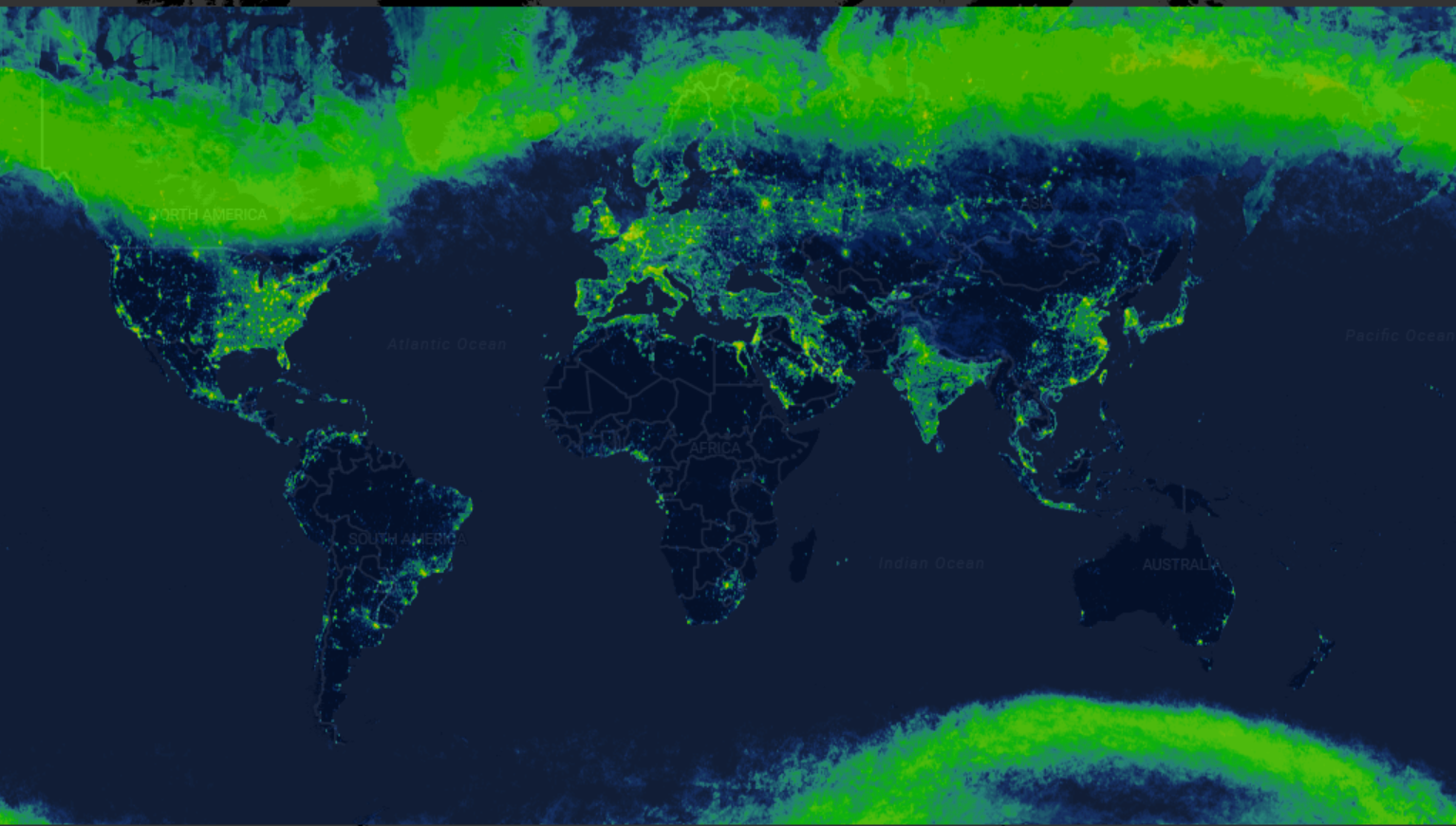
Radiance Light Trends
Radiance Light Trends is a GIS web application that is designed to quickly display information about radiance trends at a specific location (available online at https://lighttrends.lightpollutionmap.info). It uses data from two satellite systems, DM…
TIGA - Processing Center of the Tide Gauge Benchmark Monitoring Working Group
Being a modern geodetic measuring method, GNSS (Global Navigation Satellite Systems) has reached an important role in geosciences. Within the scope of the Tide Gauge Benchmark Monitoring Working Group (TIGA-WG) of the IGS, GFZ analyses and reprocess…